UN Backs Equal Earth Map to Correct Distortions in World Maps
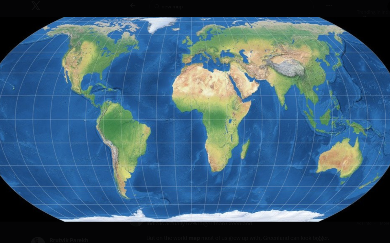
UN Backs Equal Earth Map Projection to Correct Continent-Size Distortions The United Nations General Assembly has adopted a non-binding resolution encouraging the use of equal-area world maps, including the Equal Earth projection, to show continents in proportions closer to their actual size. The resolution, led by Togo on behalf of the African Group, received support from (164) countries. The United States voted against it, while six countries abstained. The move aims to address size distortions associated with the widely used Mercator map projection. On an Equal Earth map, Africa appears significantly larger, while Greenland, Europe and North America appear smaller than on traditional Mercator maps.
Why the UN Supports Equal-Area Maps Supporters of the resolution argue that maps influence education, public understanding and perceptions of countries and continents. Togo said maps are not merely geographical tools but also shape how people understand the world and their place in it. It called for broader consideration of equal-area projections, which preserve the relative land area of continents and territories. The resolution does not ban the Mercator projection or require countries, schools or institutions to use the Equal Earth projection. Instead, it supports the wider use and consideration of maps that present land masses in more accurate proportions. France, which co-sponsored the resolution, announced that it would move away from the Mercator projection for some official uses.
Mercator vs Equal Earth Cartographer Gerardus Mercator developed the Mercator projection in (1569), primarily for maritime navigation. It preserves direction and local angles, allowing sailors to plot straight-line courses. However, the projection greatly enlarges land areas closer to the poles. Greenland can appear nearly as large as Africa on a Mercator map, even though Africa is about (14) times larger. Cartographers Bojan Šavrič, Bernhard Jenny and Tom Patterson developed the Equal Earth projection in (2018). It is an equal-area projection, which means it keeps the relative surface areas of continents closer to reality. As a result, Africa, South America, South Asia and Oceania appear more prominent. Greenland, Europe and North America look smaller because the map removes the enlargement caused by the Mercator projection. The continents have not changed size. The new projection changes how accurately their relative sizes appear on a flat map.
US Raises Objections The United States opposed the resolution, arguing that the General Assembly should focus on issues such as international peace, prosperity and relations between countries. A US representative said the resolution could undermine the UN’s credibility by focusing on map projections and what it described as an ideological agenda. Supporters rejected that argument, saying the initiative does not target any country or cartographic tradition. They said it focuses on scientific accuracy and reducing distortions in the visual representation of the world. The Mercator projection will continue to be used for navigation because of its ability to preserve direction. The UN-backed resolution instead promotes the use of equal-area maps when accurately comparing the size of countries and continents is important.
rutvik
rutvik is a Senior Journalist dedicated to bringing you the most accurate and up-to-date coverage. With a commitment to journalistic integrity and deep research, every piece is vetted for quality and truth.